May 2, 2019
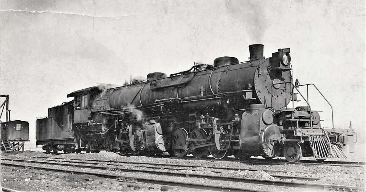
All - Per our discussion, I've attached a copy of Hol's image showing CB&Q 2-8-8-2 type No. 4200. The image came with no identification as to date or location. I'm going to plead ignorance on the track layout out of Beardstown over the Illinois River Bridge to Galesburg, or south to Centralia, but from this image, is it likely that the filthy No. 4200 is posed near the riverfront in Beardstown while in helper service? And, YES, it's central Illinois, not southern.
Further, note the elevated box car at far left being used as an office. Could that mean the tracks shown were susceptible to flooding, like from the Illinois River? Additionally, there's a clear unobstructed background behind the office that might indicate a river or large body of water. I find it hard to believe that the Q would go to the trouble and expense of elevating a box car office unless the ground below was susceptible to flooding.
There also appears to be clinker all over the ground, possibly from cleaning ash pans at an engine service area. As for all the dents on 4200's lower cylinder covers and missing foot board, any ideas on what could've caused that? Was there a deep narrow cut on either of the hills in and out of Beardstown from which fallen stones might've caused the dents?
Although Baldwin had constructed the 2-8-8-2 in 1911, this image shows it still with extended piston rods on the front low pressure cylinder, so the locomotive couldn't be all that old at the time. 1915 or so is my guess. Comments and opinions on this unique image are most welcome. Big question, is the location Beardstown or not? Best Regards - Louis
Louis Zadnichek II
Fairhope, AL
In a message dated 5/2/2019 8:34:50 AM Central Standard Time, icrr1680=yahoo.com@groups.io writes:
The bottom of "Browning Hill" was the Illinois River Bridge i.e. Beardstown.
On Wednesday, May 1, 2019 10:34 PM, Erik Spoonmore <Spoony81@att.net> wrote:
Browning was also about 12 miles from Beardstown so it wouldn’t make sense that they would have separate facilities.
Erik Spoonmore
The helpers were serviced at the Beardstown roundhouse as were the "pushers" for Azenaville Hill south of Beardstown. The latter operation lasted into the diesel era until DP. BTW, I would not call Browning "southwest Illinois" as it is clearly in CENTRAL ILLINOIS!
Louis:
I have station maps of Browning and Bader and a R/W map from Browning to Bader. None of these maps show an engine terminal per se, but all of the maps show the tracks as they existed before any trackage was removed.
Before the new line was built via Stewart between Frederic and Vermont, the original line had double track from the north side of the Illinois River bridge to just south of the depot at Browning and from just north of the depot at Bader to Bushnell. The double track is shown on the maps, and each station also had a passing siding along side the double track. Beyond the end of the double track at each station, the passing siding had a crossover back to the main and an extension to the siding that ran past the depot and tied back into single track. This extension could be used as a pocket track, presumably for the helpers. When you study the maps, particularly the station maps, I believe you will be able to picture how the helpers may have operated.
Unfortunately my maps are copied on individual sheets, not continuous, so you will have to piece them together, but you will still be able to see everything.
Let me know what you want a copy of, and I will scan it and send it to you.
Glen Haug
Sent: Wednesday, May 1, 2019 10:28 AM
To: cbq@groups.io
Subject: [CBQ] Browning Hill
May 1, 2019
Group - Does any one have a track diagram or image showing Browning Hill on the Beardstown line in southwest Illinois? Years ago, the Q kept helpers at Browning to assist trains up Browning Hill from the Illinois River Valley. Among the helpers was the Q's only 2-8-8-2, No. 4200. I'm particularly interested in knowing if there was a small yard or engine terminal for the helpers either along side or close to the Illinois River in or near Browning. Best Regards - Louis
Louis Zadnichek II
Fairhope, AL
_._,_._,_
Groups.io Links:
You receive all messages sent to this group.
View/Reply Online (#57219) |
Reply To Group
|
Mute This Topic
| New Topic
Your Subscription |
Contact Group Owner |
Unsubscribe
[archives@nauer.org]
_._,_._,_
 CBQ4200NoOtherInformation.jpg
Description: JPEG image
|